


Voting District 10005, Tehama County, California
About
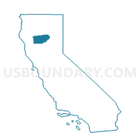
Outline

Summary
| Unique Area Identifier | 545224 |
| Name | Voting District 10005 |
| County | Tehama County |
| State | California |
| Area (square miles) | 472.20 |
| Land Area (square miles) | 472.11 |
| Water Area (square miles) | 0.09 |
| % of Land Area | 99.98 |
| % of Water Area | 0.02 |
| Latitude of the Internal Point | 40.25989050 |
| Longtitude of the Internal Point | -122.65843160 |
Maps


Graphs
Select a template below for downloading or customizing gragh for Voting District 10005, Tehama County, California


Neighbors
Neighoring Voting District (by Name) Neighboring Voting District on the Map
- Voting District 10010, Tehama County, CA
- Voting District 20020, Tehama County, CA
- Voting District 20025, Tehama County, CA
- Voting District 20190, Shasta County, CA
- Voting District 20200, Shasta County, CA
- Voting District 30045, Tehama County, CA
- Voting District 30060, Tehama County, CA
- Voting District 40090, Tehama County, CA
- Voting District 50110, Trinity County, CA
- Voting District 50470, Shasta County, CA
- Voting District 50500, Shasta County, CA
Top 10 Neighboring County Subdivision (by Population) Neighboring County Subdivision on the Map
- Redding CCD, Shasta County, CA (152,644)
- Red Bluff CCD, Tehama County, CA (40,361)
- West Tehama CCD, Tehama County, CA (4,515)
- Southwest Shasta CCD, Shasta County, CA (4,100)
- Mad River CCD, Trinity County, CA (975)
Top 10 Neighboring Place (by Population) Neighboring Place on the Map
Top 10 Neighboring Elementary School District (by Population) Neighboring Elementary School District on the Map
- Red Bluff Union Elementary School District, CA (20,337)
- Cottonwood Union Elementary School District, CA (8,632)
- Evergreen Union Elementary School District, CA (8,431)
- Reeds Creek Elementary School District, CA (1,281)
- Igo, Ono, Platina Union Elementary School District, CA (1,012)
- Bend Elementary School District, CA (937)
Top 10 Neighboring Secondary School District (by Population) Neighboring Secondary School District on the Map
- Shasta Union High School District, CA (101,215)
- Red Bluff Joint Union High School District, CA (42,667)
- Anderson Union High School District, CA (38,366)
Top 10 Neighboring Unified School District (by Population) Neighboring Unified School District on the Map
Top 10 Neighboring State Legislative District Lower Chamber (by Population) Neighboring State Legislative District Lower Chamber on the Map
Top 10 Neighboring State Legislative District Upper Chamber (by Population) Neighboring State Legislative District Upper Chamber on the Map
Top 10 Neighboring 111th Congressional District (by Population) Neighboring 111th Congressional District on the Map
Top 10 Neighboring Census Tract (by Population) Neighboring Census Tract on the Map
- Census Tract 2, Tehama County, CA (7,705)
- Census Tract 4, Tehama County, CA (5,508)
- Census Tract 122, Shasta County, CA (5,379)
- Census Tract 3, Tehama County, CA (4,515)
- Census Tract 124, Shasta County, CA (4,100)
- Census Tract 123.03, Shasta County, CA (3,913)
- Census Tract 4, Trinity County, CA (975)